OFF THE MAP


Words/Images: Noel Pietsch


Activities on Island Molokai


Molokai Island Activities


There are few places in Hawaii as isolated as the remote peninsula of Kalaupapa on the island of Molokai. This U.S. National Park is cut off from Molokai by 1,700 foot cliffs, and surrounded on three sides by the Pacific Ocean.  The Kalaupapa peninsula can only be reached by private charter plane, hiking the steep three-mile trail, or using a sure-footed Molokai Mule - a very scenic and adventurous way to visit Kalaupapa.


The Molokai Mule Ride was established in 1973 and inspired by the Grand Canyon Mule tours that take thousands of tourists into the canyon each year. Local businessmen liked the idea but were not sure if a mule could traverse the steep cliffs.  They turned to the best “mule man” in the islands, Eldon “Buzzy” Sproat, to see if a mule tour to Kalaupapa was possible.


“I was living on Oahu, and who wants to live on Oahu,” say Buzzy, who was born and raised training mules on Big Island’s Parker Ranch. “So I flew over to Molokai and was the first guy to ever ride a mule down into Kalaupapa. I wasn’t even working for the company but when I rode the mule back up, proving it was possible to start a tour, the owner gave me an offer I could not refuse,” says Buzzy.  Today Molokai Mule Ride is owned by Buzzy and his partner Roy Horner, and taking groups down into Kalaupapa six days a week on their 23 Molokai Mules.


“People always ask, what’s a mule Buzzy? And I tell them, if you think it’s a donkey, you’re half right. If you think it’s a horse, you’re half right,” says Buzzy. “But most importantly, these animals are extremely sure-footed and can be trusted to get you down and back up the trail safely.”


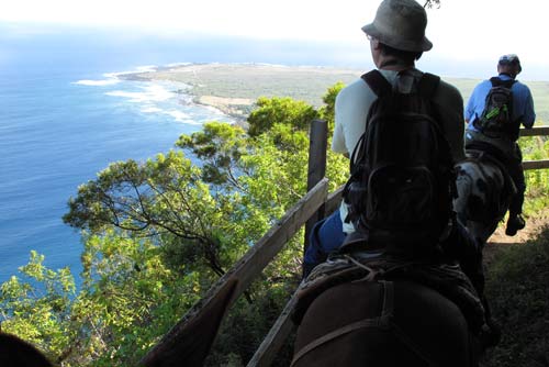
The tour begins at 8 in the morning.  Guests are given a quick briefing, introduced to their mule for the day, then helped into the saddle to head out across the paved road towards the trail to Kalaupapa. Each mule has a distinct personality, and our guide Bobby, a Hawaiian who has been leading the mule tours for over 30-years, assures us that theses mules are so well trained that  the riders can relax and enjoy the view. The trail begins by weaving in and out of a canopy of trees, past a bright green pasture and quickly to the start of the Kalaupapa trail.


“My favorite part of the ride is right at the top,” says Buzzy. “As soon as you turn the corner everybody is just taken aback because you are looking right down the cliff and out into the ocean and the Kalaupapa settlement… it’s just beautiful,” says Buzzy.  The ride continues through 26 switchbacks and in and out of the cool shade of the Hawaiian forest. The views looking down the sea cliffs and into the village of Kalaupapa are spectacular and change with every few feet traveled, keeping riders entertained for the hour-long journey down the mountain. Upon reaching the magnificent black sand beach at the base of the cliffs, the mules traverse along the trail to a small corral where the ride ends and the tour of Kalaupapa begins.


Trading in the mules for an old yellow school bus, a driver takes the group on a tour of Kalaupapa, telling stories and teaching about the difficult challenges faced by the patients. From 1866 to 1969 people from Hawaii infected with Hansen’s Disease (Leprosy) were sent to live in isolation on Kalaupapa. Some were literally thrown from boats and had to swim to shore and struggle for survival. The tour travels through the town, including the local store, the one-pump gas station, the old hospital and the homes where 18 recovered Hansen’s disease patients still live.


The tour then travels from the settlement of Kalaupapa to Kalawao, stopping at the newly restored St. Philomena Catholic Church, the site of Father Damien’s grave. Set in front of a breathtaking backdrop of magnificent sea cliffs, the historic church and graveyard brings to life both the horrific tragedy of lives lost at Kalaupapa and the incredible compassion Father Damien had for these people. The tour concludes with a picnic lunch at beautiful Kalawao, the site of the first settlement on the peninsula, before heading back to meet the mules for the quick trip back up the trail. A day exploring Kalaupapa is like a day spent back in time. It is likely the least touristed tour in Hawaii, and leaves you feeling like you got the rare chance to see a piece of living history, a part of Hawaii that has remained relatively untouched since the 1870’s.


If you are making a quick trip over to Molokai just for the mule ride into Kalaupapa its best to plan to stay the night before the tour on Molokai. The last remaining hotel, Hotel Molokai, is just a quick 20 minute drive from the Mule Ride stables and a great option for a quick overnight trip. Located on the water just five minutes from downtown Kaunakakai, the hotel and its lively restaurant, with local music nightly, completes this true kama’aina experience.


Molokai Mule Ride: www.muleride.com

Kalaupapa National Park: www.nps.gov/kala/index.htm

Hotel Molokai: www.hotelmolokai.com


Bookmark and Share


Click to Book go Mokulele Flight

HOPS KAUAI


TITLE: Waimea Stay

Words: Kristy Kinimaka


 Waimea Plantation Cottages, Kauai

Waimea Plantation Cottages


For a peaceful getaway , make sure you stay at Waimea Plantation Cottages on Kauai’s Westside. It’s like taking a step back in time to the days of the sugar plantation. The quaint cottages each have their own charming personality. The landscape of the coconut trees, banyan trees, and various island plants are well maintained and breathtaking.

You can enjoy quality time with family and friends with the conveniences of a home , as the accommodations include a kitchen, separate rooms, living room, and outdoor bbq. Lounge by the pool, laze on a hammock under a coconut tree, or walk the black sand beach and gaze into the distance to see
the forbidden island of Ni’ihau.

Waimea Canyon, Polihale Beach, and the Napali Coast are popular attractions on Kauai’s Westside. And, if you find yourself there in February, be sure to check out the Waimea Town Celebration Feb 19-20,
2010. Visit
http://www.waimeaplantation.com/


Bookmark and Share


Click to Book go Mokulele Flight

HOPS BIG ISLAND


Kona Brewing Company

Kona Brewing Company’s two pubs in Kailua-Kona on Hawaii’s Big Island and at Koko Marina Center on Oahu recently became Certified Green Restaurants® by the Green Restaurant Association. Kona Brewing Company’s two restaurants are the only current Certified Green Restaurant® locations in the state of Hawaii.


Working with the Green Restaurant Association (GRA), Kona Brewing Company received solutions, guidance and education that enabled it to improve its efforts toward reducing its environmental impact. GRA focuses on water efficiency, waste reduction and recycling, sustainable furnishings and building materials, sustainable food, energy, disposables, and chemical and pollution reduction.


Kona Brewing Company’s sustainability coordinator Tracy Solomon focused on four areas as she worked with the GRA for certification: Kona Brewing Company efforts to conserve resources, minimize waste, prevent pollution and support local agriculture. To maintain GRA status, each pub will be required to make additional advancements and be re- evaluated annually.


Find out more at www.konabrewingco.com


Bookmark and Share


HOPS BIG ISLAND


Words: Chantal Peterson

Image: Lauren Gerstle


Captain Cook Monument Big Island

Captain Cook Monument, Big Island


If you are looking for an alternative to being shuffled about en masse at the mercy of a benevolent tour guide but still want to experience one of the Big Island’s hot tourism wonders – then read carefully, for herein lies the map to a lesser known treasure.


The destination itself, located just 20 miles south of Kailua-Kona, is a well known snorkeling, kayaking and diving spot, and is home to the Captain Cook monument commemorating the “discovery” of the islands in 1779. The vibrant reef is beautiful - with 100 ft. visibility in crystal clear waters you can see a wide variety of tropical aquatic species and diverse underwater landscape. Immediately in front of the monument the coral reef forms a large shelf, extending out in less than 15 feet of water. The water gets deeper as you head south of the monument.


Tourists frequent this spot, generally arriving on boats which depart from the opposite side of the Kealakekua Bay, or with organized kayaking groups. Other tourists rent kayaks and make their way across the bay independently.


However, should you prefer a more independent, adventurous and physically demanding route to this epic snorkeling spot, you can choose to hike there. The trail is an unmarked, lesser-known gem, maintained by a local hiking enthusiast with his industrial weed whacker. The hike is difficult, but not extremely long. It drops approximately 1,300 feet in about 1.4 miles. On the trail you must watch your footing because of the slick remains of cut guinea grass, followed thereafter by somewhat loose lava rock covering the trail. The hike out is quite steep and it is not recommended in the mid-day heat; regardless of the time of day, bring lots of water and wear good shoes.


How to get there:Take Highway 11 South from Kailua-Kona until the Kealakekua turn-off (Hwy 160) at the 110.5 mile marker. Turn right and continue for 200 yards. You will see three tall palm trees on your left hand side. The unmarked trail head is directly across from those three trees, on your right hand side. You can park along the road, as there are a few spots cleared along the side of the road, presumably for this purpose. The trailhead is a small, 6 ft wide clearing just off of the paved road.


Enjoy the beauty of this natural treasure – use your body to get you there and save money at the same time. Do not forget an underwater camera!


Bookmark and Share


Click to Book go Mokulele Flight

goTeam , posted on Dec 14 2009, 08:29


Honolulu, December 14, 2009go! Mokulele today reported preliminary traffic figures for November 2009 and noted it generated 11.69 million available seat miles and 8.04 million revenue passenger miles versus 12.74 million available seat miles and 8.14 million revenue passenger miles in November 2008.  go! recorded a 68.75 percent load factor compared to 63.86 percent for the same period in 2008 while passenger enplanements were 55,996, a 0.73 percent increase over the 55,591 passengers carried in November 2008.


November Results Nov-09 Nov-08 Change
Revenue Passenger Miles (000) 8,035  8,138  -1.27%
Available Seat Miles (000) 11,688   12,744  -8.29%
Passengers Carried 55,996 55,591 0.73%
Load Factor 68.75% 63.86% 4.9 pts
 
Year-to-Date Results YTD 09 YTD 08 Change
Revenue Passenger Miles (000) 93,916 107,413 -12.57%
Available Seat Miles (000) 139,993 158,664 -11.77%
Passengers Carried 654,718 737,674 -11.25%
Load Factor 67.09% 67.70% (0.6) pts


Paul Skellon, Vice President go! said, “While year over year passenger numbers were predictably up following our recent joint venture agreement with Mokulele Airlines, prudent matching of capacity with demand remains a focus for us.” Mr. Skellon added, “I would like to thank everyone on the team for their dedication in bringing about this exciting merger in record time.”


Mesa Air Group Chairman and CEO, Jonathan Ornstein said, “In spite of the impact that the current economic climate has had on Hawaii’s tourism industry, I remain optimistic that as conditions improve, go! Mokulele is well positioned to succeed as Hawaii’s only low cost carrier.” Mr. Ornstein continued, “Each of us at go! Mokulele reaffirm our commitment to serving the people and businesses of Hawaii with friendly, convenient service and affordable air fares. We thank you for your business and continued support and extend the warmest holiday greetings to each of our customers and partners.”


go! Home for the Holidays with our special low fares. Fares begin at $58* each-way (not including government taxes and fees, restrictions apply). With up to 108 daily flights, easily share in the special moments of the season without breaking your holiday budget. Visit www.iflygo.com for details.

HAWAII FORCES OF NATURE


WHERE DO [RAINBOWS] COME FROM?


1.      A rainbow is the amazing product of the interaction between the two fundamentals of life: light and water

2.  Rainbows are created when light is refracted or bent by raindrops – reflecting the light back to your eyes.

3.  Each color is refracted at a different angle, which allows for the separation of the colors

4.  The sun is always directly behind you when you look in the direction of a rainbow.

5.  Usually you cannot observe the entire circle of a rainbow because the earth gets in the way.

6.  The double rainbow (or supernumerary rainbow) can be seen when the sunrays follow slightly different paths through the same raindrops.   

7.  Two people can never see the same rainbow because the raindrops are always moving and the light is different depending on each persons time and place.  

8.  Kahalapuna, the legendary maiden from Manoa Valley, also goes by the name of Kaikawahine Anuenue; the Rainbow Maiden.

   WHERE DO [CORALS] COME FROM?


Although coral feels like rock and looks like a plant, it is actually classified as an animal.

- A coral polyp consists of tentacles, a mouth, and a gut.

- Coral utilizes calcium carbonate from the ocean to build its skeletal structure.

- As oceans acidify, due to increases in CO2 levels, it becomes more challenging for coral to build and maintain its shell structure.

- The largest known coral reef is the Great Barrier Reef located off the coast of Australia.

- About 85 percent of the United States’ coral reef can be found in Hawai‘i. (The acres of coral reef found in Hawai‘i more than double the landmass of the islands.)

- Coral reef ecosystems demonstrate the second most amount of biodiversity (tropical rain forests are first).

- You can destroy a 100-year-old piece of coral with one careless step. 


WHERE DO [WAVES] COME FROM?


 Waves are created by wind energy, and wind energy is created by sun energy. Sun energy heats up one side of the planet or one particular climate. As the air warms, it rises, and cold air fills in the gap. As the cold air rushes in, it creates what we call wind. 


- The highest point of a wave is the crest, the lowest point is the trough. A wavelength is measured from crest to crest or trough to trough.


-The longer the wavelength, the longer you wait for a wave to surf.


- During peak season (November-February) waves on the North Shore of O‘ahu can reach up to fifty feet face.


- You can measure a wave from the back (Hawaiian measurement) or the front (the wave face). The Hawaiian measurement is around half the height of the face, but it depends on who you talk to. 


- Measuring waves Hawaiian style is a good way to deter surfers from crowding the ocean because the waves seem smaller.


- Measuring waves from the face is a good way to deter tourists from hitting the surf because the waves seem bigger.


- Waves just keep on coming, making them a potential source of alternative energy.


Bookmark and Share


Click to Book go Mokulele Flight